Adds a marker and label to the current 3D plot
render_label(
  heightmap,
  text,
  lat,
  long,
  altitude = NULL,
  extent = NULL,
  x = NULL,
  y = NULL,
  z = NULL,
  zscale = 1,
  relativez = TRUE,
  offset = 0,
  clear_previous = FALSE,
  textsize = 1,
  dashed = FALSE,
  dashlength = "auto",
  linewidth = 3,
  antialias = FALSE,
  alpha = 1,
  textalpha = 1,
  freetype = TRUE,
  adjustvec = NULL,
  family = "sans",
  fonttype = "standard",
  linecolor = "black",
  textcolor = "black"
)
Arguments
- heightmap
A two-dimensional matrix, where each entry in the matrix is the elevation at that point. All points are assumed to be evenly spaced.
- text
The label text.
- lat
A latitude for the text. Must provide an
raster::extentobject to argumentextentfor the map.- long
A latitude for the text. Must provide an
raster::extentobject to argumentextentfor the map.- altitude
Default
NULL. Elevation of the label, in units of the elevation matrix (scaled by zscale). If none is passed, this will default to 10 percent above the maximum altitude in the heightmap.- extent
Either an object representing the spatial extent of the scene (either from the
raster,terra,sf, orsppackages), a length-4 numeric vector specifyingc("xmin", "xmax","ymin","ymax"), or the spatial object (from the previously aforementioned packages) which will be automatically converted to an extent object.- x
Default
NULL. Directly specify thexindex in the matrix to place the label.- y
Default
NULL. Directly specify theyindex in the matrix to place the label.- z
Default
NULL. Elevation of the label, in units of the elevation matrix (scaled by zscale).- zscale
Default
1. The ratio between the x and y spacing (which are assumed to be equal) and the z axis. For example, if the elevation levels are in units- relativez
Default
TRUE. Whetherzshould be measured in relation to the underlying elevation at that point in the heightmap, or set absolutely (FALSE).- offset
Elevation above the surface (at the label point) to start drawing the line.
- clear_previous
Default
FALSE. IfTRUE, it will clear all existing text and lines rendered withrender_label(). If no other arguments are passed torender_label(), this will just remove all existing lines.- textsize
Default
1. A numeric character expansion value.- dashed
Default
FALSE. IfTRUE, the label line is dashed.- dashlength
Default
auto. Length, in units of the elevation matrix (scaled byzscale) of the dashes ifdashed = TRUE.- linewidth
Default
3. The line width.- antialias
Default
FALSE. IfTRUE, the line with be have anti-aliasing applied. NOTE: anti-aliasing can cause some unpredictable behavior with transparent surfaces.- alpha
Default
1. Transparency of the label line.- textalpha
Default
1. Transparency of the label text.- freetype
Default
TRUE. Set toFALSEif freetype is not installed (freetype enables anti-aliased fonts). NOTE: There are occasionally transparency issues when positioning Freetype fonts in front and behind a transparent surface.- adjustvec
Default
c(0.5,-0.5). The horizontal and vertical offset for the text. Iffreetype = FALSEand on macOS/Linux, this is adjusted toc(0.33,-0.5)to keep the type centered.- family
Default
"sans". Font family. Choices arec("serif", "sans", "mono", "symbol").- fonttype
Default
"standard". The font type. Choices arec("standard", "bold", "italic", "bolditalic"). NOTE: These require FreeType fonts, which may not be installed on your system. See the documentation for rgl::text3d() for more information.- linecolor
Default
black. Color of the line.- textcolor
Default
black. Color of the text.
Examples
if(run_documentation()) {
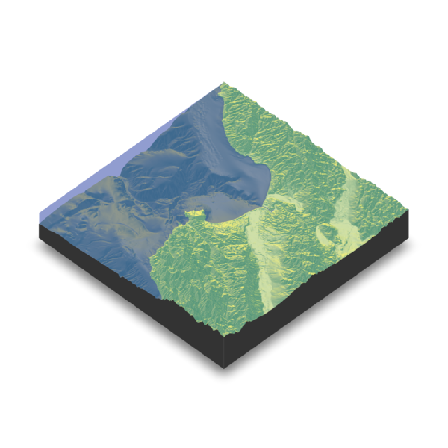
montereybay |>
sphere_shade() |>
plot_3d(montereybay,zscale=50,water=TRUE, watercolor="#233aa1",
zoom=0.9, windowsize = 800)
render_snapshot()
}
 santa_cruz = c(36.962957, -122.021033)
#We want to add a label to Santa Cruz, so we use the x and y matrix coordinate (x=220 and y=330)
if(run_documentation()) {
render_label(montereybay,lat = santa_cruz[1], long = santa_cruz[2],
extent = attr(montereybay, "extent"), textsize = 2,
altitude=12000, zscale=50, text = "Santa Cruz")
render_snapshot()
}
santa_cruz = c(36.962957, -122.021033)
#We want to add a label to Santa Cruz, so we use the x and y matrix coordinate (x=220 and y=330)
if(run_documentation()) {
render_label(montereybay,lat = santa_cruz[1], long = santa_cruz[2],
extent = attr(montereybay, "extent"), textsize = 2,
altitude=12000, zscale=50, text = "Santa Cruz")
render_snapshot()
}
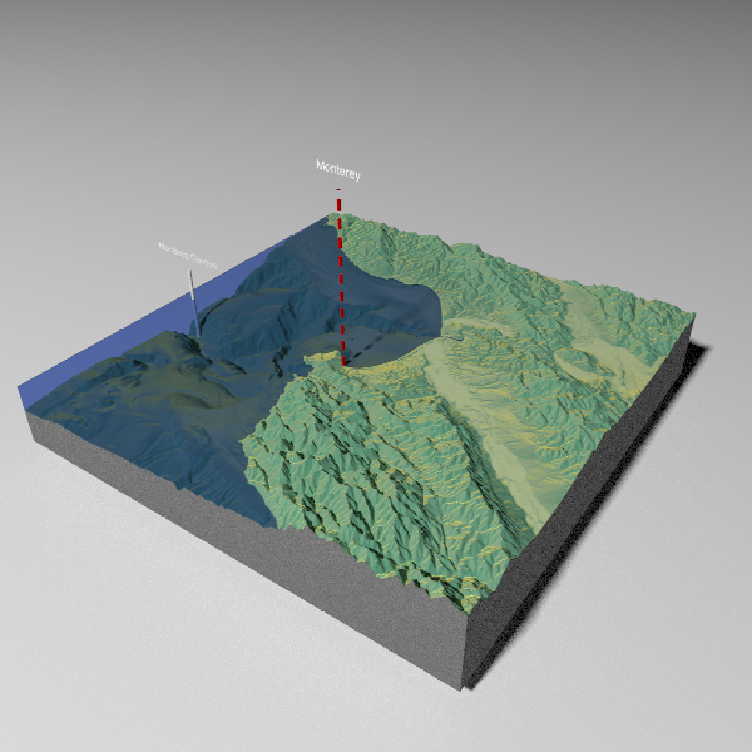
 monterey = c(36.603053, -121.892933)
#We can also change the linetype to dashed by setting `dashed = TRUE` (additional options allow
#the user to control the dash length). You can clear the existing lines by setting
#`clear_previous = TRUE`.
if(run_documentation()) {
render_label(montereybay, lat = monterey[1], long = monterey[2], altitude = 10000,
extent = attr(montereybay, "extent"), textsize = 2,
zscale = 50, text = "Monterey", textcolor = "white", linecolor="darkred",
dashed = TRUE, clear_previous = TRUE)
render_snapshot()
}
#> Error in validate_mesh(scene): !any(is.na(normals)) is not TRUE
canyon = c(36.621049, -122.333912)
#By default, z specifies the altitude above that point on the elevation matrix. We can also specify
#an absolute height by setting `relativez=FALSE`.
if(run_documentation()) {
render_label(montereybay,lat=canyon[1], long = canyon[2], altitude = 2000,
extent = attr(montereybay,"extent"), textsize = 2,
zscale=50,text = "Monterey Canyon", relativez=FALSE)
render_snapshot()
}
#> Error in validate_mesh(scene): !any(is.na(normals)) is not TRUE
#We can also render labels in high quality with `render_highquality()`, specifying a custom
#line radius. By default, the labels point towards the camera, but you can fix their angle with
#argument `text_angle`.
if(run_documentation()) {
render_camera(theta=35, phi = 35, zoom = 0.80, fov=60)
render_label(montereybay, lat = monterey[1], long = monterey[2], altitude = 10000,
extent = attr(montereybay, "extent"), textsize = 2,
zscale = 50, text = "Monterey", textcolor = "white", linecolor="darkred",
dashed = TRUE, clear_previous = TRUE)
render_label(montereybay,lat=canyon[1], long = canyon[2],
altitude = 2000, zscale=50, textsize = 2,
extent = attr(montereybay,"extent"), textcolor = "white", linecolor="white",
text = "Monterey Canyon", relativez=FALSE)
render_highquality(samples = 16,text_size = 64, line_radius = 3, text_offset = c(0, 20, 0),
lightdirection = 180, min_variance = 0)
}
monterey = c(36.603053, -121.892933)
#We can also change the linetype to dashed by setting `dashed = TRUE` (additional options allow
#the user to control the dash length). You can clear the existing lines by setting
#`clear_previous = TRUE`.
if(run_documentation()) {
render_label(montereybay, lat = monterey[1], long = monterey[2], altitude = 10000,
extent = attr(montereybay, "extent"), textsize = 2,
zscale = 50, text = "Monterey", textcolor = "white", linecolor="darkred",
dashed = TRUE, clear_previous = TRUE)
render_snapshot()
}
#> Error in validate_mesh(scene): !any(is.na(normals)) is not TRUE
canyon = c(36.621049, -122.333912)
#By default, z specifies the altitude above that point on the elevation matrix. We can also specify
#an absolute height by setting `relativez=FALSE`.
if(run_documentation()) {
render_label(montereybay,lat=canyon[1], long = canyon[2], altitude = 2000,
extent = attr(montereybay,"extent"), textsize = 2,
zscale=50,text = "Monterey Canyon", relativez=FALSE)
render_snapshot()
}
#> Error in validate_mesh(scene): !any(is.na(normals)) is not TRUE
#We can also render labels in high quality with `render_highquality()`, specifying a custom
#line radius. By default, the labels point towards the camera, but you can fix their angle with
#argument `text_angle`.
if(run_documentation()) {
render_camera(theta=35, phi = 35, zoom = 0.80, fov=60)
render_label(montereybay, lat = monterey[1], long = monterey[2], altitude = 10000,
extent = attr(montereybay, "extent"), textsize = 2,
zscale = 50, text = "Monterey", textcolor = "white", linecolor="darkred",
dashed = TRUE, clear_previous = TRUE)
render_label(montereybay,lat=canyon[1], long = canyon[2],
altitude = 2000, zscale=50, textsize = 2,
extent = attr(montereybay,"extent"), textcolor = "white", linecolor="white",
text = "Monterey Canyon", relativez=FALSE)
render_highquality(samples = 16,text_size = 64, line_radius = 3, text_offset = c(0, 20, 0),
lightdirection = 180, min_variance = 0)
}
 if(run_documentation()) {
#Fixed text angle
render_highquality(samples = 16,text_size = 64, line_radius = 3, text_offset = c(0, 20, 0),
lightdirection = 180, text_angle = 0, min_variance = 0)
}
if(run_documentation()) {
#Fixed text angle
render_highquality(samples = 16,text_size = 64, line_radius = 3, text_offset = c(0, 20, 0),
lightdirection = 180, text_angle = 0, min_variance = 0)
}
 #We can remove all existing labels by calling `render_label(clear_previous = TRUE)`
if(run_documentation()) {
render_label(clear_previous = TRUE)
render_snapshot()
}
#We can remove all existing labels by calling `render_label(clear_previous = TRUE)`
if(run_documentation()) {
render_label(clear_previous = TRUE)
render_snapshot()
}
